China’s satellites over West Asia: A silent shield for Iran
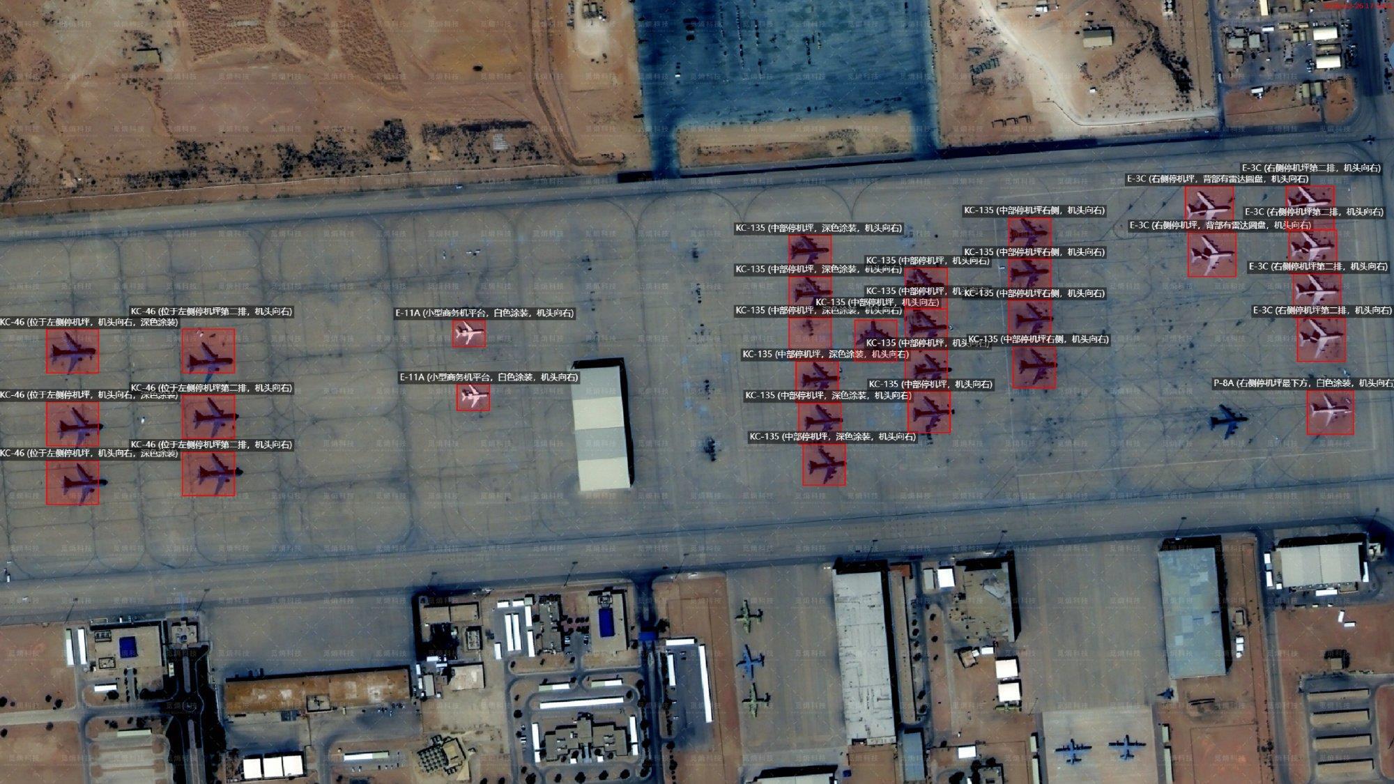
When MizarVision began publishing satellite images of the US force buildup in the Persian Gulf and Jordan ahead of the US-Israel war on Iran that began on February 28, 2026, the internet reacted instantly. The photographs circulated widely because they revealed something western providers had carefully avoided showing.

For years, companies such as Planet Labs and Maxar filtered or withheld imagery deemed sensitive to US and Israeli interests. The public rarely gained access to unvarnished visuals of American deployments in West Asia. MizarVision disrupted that pattern and forced those deployments into the open.
Obvious questions followed: Why would a Chinese firm release material that western corporations consistently suppress? Who is behind MizarVision? Why is this Chinese company publishing sensitive images that the public has never seen before?
MizarVision, according to publicly available information, is a reseller of images captured by privately owned Chinese satellites. Yet, since Beijing pre-authorizes the release of sensitive information, its motives for doing so have raised eyebrows.
The roles of China’s satellite fleet in monitoring US and Israeli activity, and in helping Yemen’s Ansarallah-aligned forces and Iran’s military during the 12-day US-Israeli war on the Islamic Republic last June, are suspected by American and Israeli diplomats and security professionals; however, the broader public was mostly unaware, assuming that Iran obtained images for military purposes from its own military satellites.
Iran operates a modest satellite program. It lacks the density, redundancy, and persistent coverage required for sustained high-resolution military intelligence. Just as Israel depends on US reconnaissance architecture, Iran leans on a technologically advanced partner able to provide continuous surveillance and rapid tasking.
That partner is China.
China’s orbital advantage
Iran has 14 active satellites listed in the US-controlled NORAD online catalogue (inactive satellites are noted by NORAD as “decayed”). In general, satellites are launched into different altitudes, which range from hundreds of kilometres to 36,000 kilometres in space, and maneuvered into their designated orbits. Some satellites are placed in “geostationary orbit” (GEO) to cover a region day and night.
GEO satellite coverage area – “footprint” – can be quite extensive. The most common type of satellites – “low earth orbit” (LEO) – traverse an orbital path, but have a smaller footprint over the area that it passes (a pass lasts from minutes to hours).
“Payload” – the technology on board – determines what a satellite can or cannot do. Iran’s recently-launched “Jam-e Jam” satellite is GEO, but its payload is for telecommunications. Just a handful of Iran’s LEO satellites have imaging capabilities, but only one has high-quality imaging technology. This is why Iran needs a partner-nation.
China’s position is entirely different. Its satellite fleet is estimated at between 1,100 and 1,350 active units spanning GEO, LEO, and specialized orbital tracks such as those supporting BeiDou navigation. Military and commercial platforms operate side by side. Many civilian-labelled satellites are dual-use by design. Any platform capable of resolving the details of a soccer stadium can just as readily map a military compound.
The breadth of the Chinese constellation enables continuous imaging, radar penetration through cloud cover, signals intelligence collection, meteorological tracking, telecommunications, and data relay. In scope and sophistication, the network stands alongside the system managed by the US National Reconnaissance Office, which underwrites American and Israeli strategic dominance.
China’s orbital infrastructure is vast, layered, and increasingly assertive in its use.
MizarVision does not launch or operate satellites. Its founder, Liu Ming, holds 35.38 percent of the company, while private investment funds control the remaining shares. No formal state fund appears on the shareholder registry, yet regulatory oversight in China ensures alignment with national priorities.
MizarVision buys imagery from the European Space Agency (ESA) and six privately-owned Chinese satellite owners and operators. As with the images at issue, MizarVision may annotate them before selling them. One Chinese company is of interest: Chang Guang Satellite Technology, Ltd., a commercial spinoff from the Chinese Academy of Sciences.
Chang Guang owns and operates a family of satellites called “Jilin-1.” There are about 120 active units according to a 2024 estimate, but probably higher since China has an intensive satellite program and is frequently orbiting new satellites.
Jilin-1 satellites specialize in high-frequency imaging and operate in coordinated clusters of five to 10 units. Panchromatic systems combine visible and infrared bands to generate grayscale imagery with resolutions between 50 and 75 centimetres. Multi-spectral systems provide colour imagery at two to three meters. High-definition video capability reaches 92 to 120 centimetres resolution, producing clips that can last from 30 to 120 seconds at roughly 10 frames per second. The satellites function in all weather conditions.
Orbiting in LEO at approximately 535 kilometres, Jilin-1 satellites maintain constant activity and do not power down at night. Cluster coordination allows persistent coverage, rapid retasking, and multiple revisits over the same region within a single day.
They are agile, satellites tilt and manoeuvre to capture the best images. Clusters allow for multi-tasking and “persistent coverage” (24/7/365). They are ideal for monitoring locales day and night.
Chang Guang, however, is not strictly private. The images their satellites acquire are utilized by China’s armed forces (PLA). A majority of Jilin-1 satellites are dedicated to regional surveillance, including West Asia.
A message delivered from orbit
The MizarVision images are almost certainly from Jilin-1. The published images are scaled down; that is, image quality has been reduced from “military grade” to commercial quality (or possibly lower, given the blurriness of several images) to obscure from China’s enemies the quality of a satellite’s imaging technologies and its tilt and manoeuvre capabilities.
Why Jilin-1? Because Chang Guang has been supplying Russia with imagery for the Ukraine War, which led to it being sanctioned by the US Government. In April 2025, the US State Department admitted at a press briefing that Chang Guang had been supplying Yemen’s Ansarallah. Moreover, the State Department briefer said the US Government had been engaging with Beijing to prevent cooperation between China and Ansarallah:
“We can confirm the reporting that Chang Guang Satellite Technology Co., Ltd. is directly supporting Iran-backed Houthi terrorist attacks on U.S. interests. Their actions and Beijing’s support of the company, even after our private engagements with them, are yet another example of China’s empty claims to support peace. We urge our partners to judge the Chinese Communist Party and Chinese companies on their actions, not their empty words. Restoring freedom of navigation in the Red Sea is a priority for [US] President Trump. Beijing should take this priority seriously when considering any future support of CGSTL. The United States will not tolerate anyone providing support to foreign terrorist organizations, such as the Houthis.”
Washington framed the cooperation as destabilizing interference. Beijing treated it as a sovereign partnership within a shifting multipolar order.
Why publish?
The publication of the Persian Gulf buildup images served two strategic functions. It exposed preparations for war that US officials would have preferred to manage quietly, and it demonstrated that those preparations were being tracked in detail. Daily or near-daily releases allowed observers worldwide to follow deployments almost in real time, fuelling public debate even as Washington pressed ahead.
Another reason for their publication was to alert the Americans and the Israelis to China’s support for Iran. Beijing’s role in supplying Iran with satellite-based “Intelligence, Surveillance, and Reconnaissance” (ISR) had been suspected, but it was never confirmed either by Iran or China.
When US President Donald Trump asserted that most of the 14 Iranian missiles failed to strike the US’s Al-Udeid Air Base in Qatar, Tehran refrained from publishing bomb damage assessment imagery that could have rebutted the claim. A western satellite firm eventually circulated images contradicting Washington’s narrative. Beijing’s recent posture suggests that future episodes may unfold differently.
The message embedded in the satellite releases requires little interpretation. Chinese systems track the placement of THAAD and Patriot batteries. They record aircraft positioning across regional bases. They observe force concentrations before they mobilize.
In contemporary warfare, information dominance shapes the battlefield before the first missile launches.
China has signalled that it possesses that vantage point.
yogaesoteric
March 7, 2026