Outside the circle: the ancient Stonehenge landscape – a wider perspective
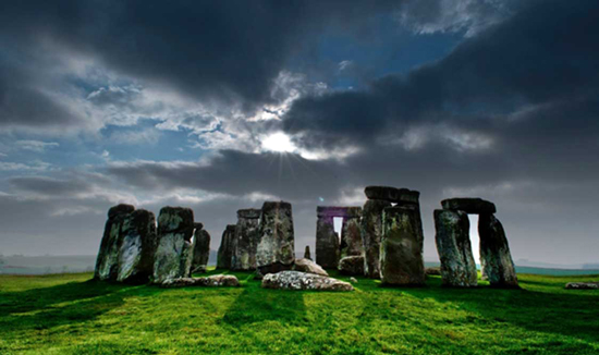
Stonehenge stands on the windswept Salisbury Plain reminding us of the engineering, astronomical, and mathematical skills of our distant ancestors.
Undoubtedly, Stonehenge is recognised worldwide as one of Britain’s most iconic stone circles. Yet, Stonehenge is a part of a much wider ceremonial landscape that contains some of the most enigmatic and mysterious monuments ever constructed.
Stonehenge has its origins rooted in antiquity. Around 10,000 years ago the Mesolithic peoples of Salisbury Plain created a thriving community close to where Stonehenge would eventually stand some five thousand years later.
Totem poles or temple structure?
In the old visitor’s car park next to Stonehenge are three large white circular markers which signify the position of Mesolithic postholes. Excavated in the 1960s these timber features were interpreted as ‘totem poles’ which instantly conjures up an image of free standing timbers of no complexity.
However, laboratory carbon dating sent a shock wave through the archaeological community as the postholes dated from 8800 BC; although one post may have been a later addition.
Aligned to face the direction of the spring and autumn equinoxes, the posts that once stood 14 feet high, reveal astronomical precision at a time when we are told that prehistoric communities were hunter-gathers. Granted, at sites such as Goblecki Tepe megalith temples were constructed during the Mesolithic era; the Far East being considered the cradle of civilization, however, ancient Britain was seen as a primitive backwater.
What did the posts signify and were they a section of a much wider timber structure – a temple complex? Questions abound as the excavation had many flaws. In 1988, some thirteen years after the initial excavation, a fourth posthole was discovered suggesting that other features may have been missed. Labelling timber posts ‘totem poles’ robs our prehistoric ancestors of their ingenious skills which will soon become evident.
Mesolithic Buildings
Close to Stonehenge is Vespasian’s Camp, an Iron Age hill fort which was a Druidic ceremonial centre dated to 500 BC. In 2005, at the base of the camp, archaeologists unearthed yet more surprises about our distant Mesolithic past. Thought to be nomadic wanderers that followed game and wild herds, Mesolithic people roamed the British landscape and lived in temporary huts or dwellings. However, new evidence dismissed this old opinion from which a new view of UK’s remote past emerges.
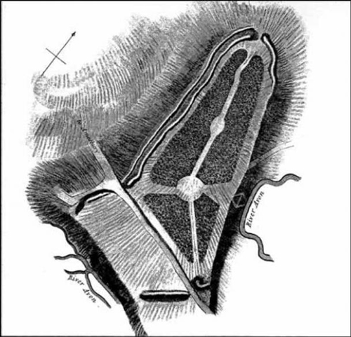
Vespasian’s Camp, an Iron Age hill fort
Close to an old spring, a Mesolithic building was recently discovered which is the oldest known building in the Stonehenge landscape. This find is unprecedented as it was believed that no such structure should exist; as Mesolithic people were thought to be nomadic. It was interpreted as a ‘home base’ or campsite that people returned to seasonally.
Certainly, the spring was deemed sacred as numerous Mesolithic deposits were placed in the water. Over 10,000 Mesolithic implements such as tools were excavated from the spring and remarkably the tools were in pristine condition.
Indeed, the blades were so sharp that some of the archaeologists cut their fingers on the razor-sharp edges. For millennia, the spring continued to be revered as deposits from the Neolithic, Bronze and Iron Ages were found alongside ritual deposits of the later Romano-British era. This was hallowed ground revered since the dawn of time.
We are spoon-fed by historians that the Mesolithic people lived in wigwam like structures following wild animals and foraging for nuts and wild berries. Not so. People lived in the so-called home base for over 1500 years as occupation spanned from 6250 – 4700 BC. This was no short-lived affair and over 62 generations lived and worshipped close to Stonehenge and its Lourdes like spring.
Evidently, it was the Mesolithic people that chose and consecrated the location of Stonehenge long before a single stone was raised by their Neolithic descendants.
3800 BC a New Monument Emerges
Around 3800 BC, (if the archaeological dating system is correct and many anomalous findings questions this) a new monument suddenly emerged that still defies explanation.
When guides take people into the Stonehenge landscape they always point out where a monument called the Cursus was located. Cursus monuments were common in Neolithic Britain and one gigantic example stood around 875 yards (800m) north of Stonehenge. Although Cursus monuments preceded the stone circle-building phase by over a thousand years, they are intimately associated with them.
The Greater Cursus (OS MAP 184.124430)
Cursus monuments are intriguing. Constructed out of chalk blocks creating large wall-like banks, the monument consisted of two roughly parallel banks and ditches around 310ft (100m) wide that coursed for nearly 2 miles (3km).
They take their name from the XVIII century antiquarian, William Stukeley, who believed them to be Roman racetracks. Cursus is Latin for running and movement.
The only illustration which depicts the monument, drawn by Stukeley, is inaccurate as the terminal end was not rounded as shown, but perfectly square. Today, little exists of the Cursus monument which was aligned east-west facing the equinox sunrise.
Strangely, the Cursus did not have an entrance and clearly was not intended to be used by the community, making it even more unique and mysterious. To add to the puzzle, a 137 yard (125m)-long extension was added to the west end, terminating in a very deep, straight ditch. The elongated interior covered 70 acres, enough to accommodate three-dozen football pitches laid out end to end.

Originally, the Cursus would have gleamed white, its chalk banks glistening in the sun and moonlight amid a lush green landscape. There are many other Cursus monuments in Britain, the largest of which is found in Dorset and courses for over 7 miles (10km).
Half a mile (800m) north-west of the Greater Cursus was once the Lesser Cursus, which ran for a quarter of a mile (400m). Both monuments were ploughed out to make way for agricultural development just after WWII.
In plain, Stonehenge and the Cursus formed a gigantic triangle; the tip balanced on Stonehenge with the long base of the Cursus half a mile (800m) to the north.
Stonehenge is almost, but not quite due south of the centre of the Cursus. No matter what type of monument and no matter where it is found – from the pyramids of ancient Egypt to the Stonehenge environs – archaeologists state that they were constructed as burial tombs or they were intimately associated with death rites – an unsatisfactory explanation for such an unusual monument, which has never revealed bones, ashes or any funerary evidence.
Rather, this vast landscape monument appears more like a container, an object constructed for technological and advanced purposes devoid of human participation and hence no entrance.
Radiation Levels
During 1995 – 1999, several gamma radiation readings were taken at the centre of the Cursus monument using a Geiger counter. Inexplicably, readings flared up compared to the stable and consistent readings obtained from the control zone which was located directly outside of the monument.
Adding to the mystery, readings tended to flare at the equinoxes mirroring its solar east-west alignment. The Cursus may well have been aligned to accommodate the gamma radiation bursts which are seemingly activated by the Sun’s movement along the ecliptic. Were these people prehistoric physicists that harnessed radiation for energy purposes, who understood the hidden energies within the landscape?
The Rollright stone circle in Oxfordshire is another example of a prehistoric site associated with radiation which it is investigated.
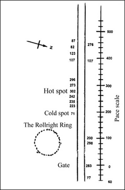
Gamma ray counts on the ‘Spook’ road
The survey below reveals the measurements which researchers took along the adjacent road to the Rollright stone circle, which was dubbed the ‘Spook road’. The normal background count for the region is 60 – 80 counts per minute. The findings revealed huge differences ranging from a cold spot of 71 to a high spot of 302.
Close to the ‘hot spot’ zone many people have reported strange phenomena. A surveyor observed the sudden disappearance in the lane of a car with two occupants and one scientist observed the momentary appearance of a huge dog-like animal by the lane next to the stone circle. Like the car image, it too vanished.
Some eighteen months later, one researcher witnessed the appearance of an old-fashioned, horse-drawn gypsy caravan for a few moments. It was going away from her yet nothing had passed her in the lane. In all these cases the witnesses, and the images observed, were in the highly radioactive sections of the lane.
A possible explanation could be that the witnesses had each experienced a ‘time-slip’ phenomenon in that, somehow, they had each gained a fleeting access to a few moments of other times in the lane, due to the high radioactive levels interacting with their minds resulting in manifestation.
Reported by military personal, are instances of time-slips by the lane that runs from Larkhill to Stonehenge. Interestingly, the lane cuts through the Cursus and is exceptionally close to the Cursus radiation ‘hot spot’.
After witnessing a strange amber or orange coloured light that suddenly appeared around their parked car, and then moved towards the main road, two soldiers that were trained observers, tried to triangulate the distance of the amber object but it suddenly disappeared. They returned to barracks. Instantly, they were reprimanded as they had been absent without leave for two days, but to the soldiers only an hour or so had passed. The soldiers are still seeking answers to this strange experience amid the Cursus monument.
Woodhenge (OS MAP 184.150434)
The Stonehenge environs contains monument after monument testifying to its importance as a prehistoric spiritual capital. Woodhenge is a large timber structure which was believed to be a flattened barrow until Squadron Leader Insall took a series of aerial photographs which showed circular white marks (now depicted by concrete posts).
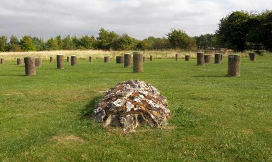
Situated a mile (1.5km) from Stonehenge, Woodhenge was a vital component of the Stonehenge landscape that was constructed around 4,200 years ago. This early Bronze Age site consisted of six ovals of concentric timber posts surrounded by a ditch and an outer bank, which was broken by an entrance causeway in the north-east – the direction of the midsummer sunrise.
Ring C was the first series of posts to be erected – 16 one-meter-thick posts each weighing around 5 tons were set in an oval-shaped pattern. In pristine condition, the monument would have appeared like a maze and it isn’t easy to walk around. However, when walked as a labyrinth it makes easy walking and perfect sense. You don’t bang into posts!
Within the inner timber ring was the grave of a young child as shown in the photograph above. An unexpected archaeological discovery in the Stonehenge environs unearthed five children’s skulls that showed evidence of head-binding or possibly elongated skulls, which is exceptionally rare for prehistoric Britain.
Woodhenge is sited on extraordinary earth energy patterns and the site is crisscrossed by linear ley lines that link monument after monument across the ceremonial landscape. Intriguingly, many of the meandering currents of earth energy terminate at the Cursus monument
Durrington Walls (OS MAP 184.150437)
Close to Woodhenge is Durrington Walls which was once a thriving and bustling Neolithic town that was later transformed into a superhenge monument. A henge is defined as an enclosure surrounded by an internal ditch and outer earthen bank which is quintessentially British. During the Late Neolithic (c2600 BC), a vast circular town, probably the biggest in Europe, was constructed.
Archaeological evidence suggests that the town was used by the people who built Stonehenge. Hundreds of houses, which had hearths, wooden furniture and beds, as well as storage units and larders, have been excavated. It is estimated that as many as 300 houses may survive beneath the henge bank and await future excavations.
A vast and exceptionally wide paved avenue road led directly to the River Avon – water is always associated with ancient sites; whether it is deep underground water born within the Earth, as stated by water diviners, rainfall collected in aquifers or surface water such as springs or rivers.
Underground water produces changes to the air and to the electromagnetic field. Certainly, wherever researchers locate particular types of earth energy associated with underground water, using the medium of dowsing, and they test the location for ionisation readings, they continually discover higher than average negative ion emissions – which are generally deemed good for people’s health.
Remarkably, there is also a radical depletion of positive ions – said to be generally detrimental to one’s sense of well-being. These energy patterns and negative ionisation hot spots are associated with either timber or megalith features within temple spaces or large Neolithic residential houses. It appears that the prehistoric populous knew where to build residential and temple constructs that would promote health and well-being, a unique design canon which modern man should adopt.
Incidentally, the Durrington road dwarfed a modern-day A-road (a UK term for a wide road) that has a carriageway some 11 yards (10m) wide; the Neolithic road was 33 yards (30m) broad.
A Superhenge
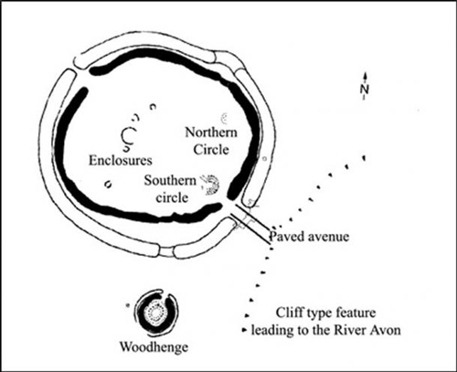
Around c2500 BC, the area was transformed, the town and its houses were decommissioned and closed down and the largest henge monument in Europe was raised. It consisted of a 16 ft (5.5m) deep ditch and an external bank, and within the site stood two rings of gigantic timber posts. Originally, the superhenge had four entrances of which the north and the south were blocked off around 2000 BC. Archaeologists believe the south entrance led to Woodhenge. Today, little exists of this former and magnificent superhenge.
Timber Stonehenge
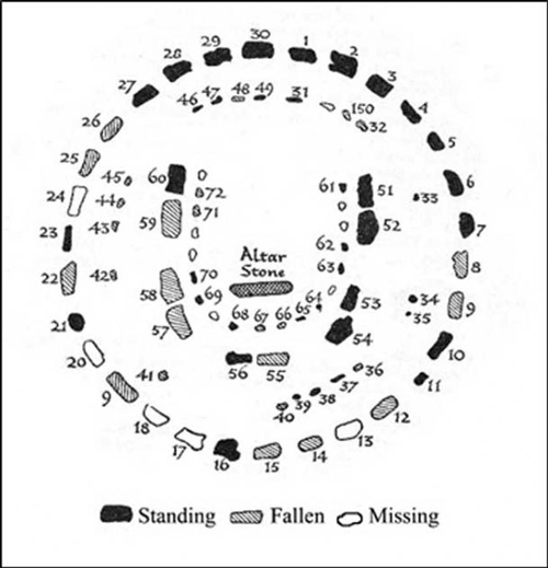
Inside the superhenge were two timber circles both of which were in view of Woodhenge and contemporary to it, and Stonehenge. The southern timber circle was a replica of Stonehenge, sharing remarkable similarities. Stonehenge contains a megalithic horseshoe setting and so did its timber counterpart.
However, the southern timber circle faced the opposite direction to the Stonehenge horseshoe feature – to the midwinter sunset. The outer circle of timbers was equivalent to Stonehenge’s sarsen circle and had the same number of uprights – thirty in all.
Unmistakably, the two structures were built from the same blueprint, one in wood and the other in stone, except the horseshoe shaped arrangement faced the opposite direction as if mirroring one another. If this monument had survived the ravages of time, it would be considered a world wonder.
Other Local Structures
Large wooden structures were located nearby that may well prove to be additional temple structures. One construct was surveyed just after WWII by the field archaeologist and Master Dowser Guy Underwood. He located a rectangular structure just outside of the Durrington superhenge. This was 60 years before archaeologists discovered the rectangular buildings associated with domestic activity at Durrington.
During the 1940s it was thought that prehistoric Britons lived in circular structures as did their Iron Age descendents. Further investigations revealed that the timber structure may have been two-stories high from which you could see every monument within the Stonehenge environs including the stone circle. Had the timber structure been placed just a few meters either side, the contours of the land would have obscured the perfect view.
Beneath the surface and hidden from view are probably far more buildings, stone holes where large standing stones once stood proudly reaching for the Sun, and numerous timber structures await excavation. For instance, close to the River Avon, a gigantic platform raised to around two stories high was recently unearthed. Once more in true archaeology style, it was interpreted as a platform to place a deceased corpse upon.
What are these structures and why were they constructed? This was the land of the living, alive with ingenious inventions with skilled people that constructed stone and timber monuments that possessed extraordinary engineering skills.
More Than Meets the Eye
This monumental landscape has been regarded as an epicentre of global importance for over 10,000 years. The Stonehenge environs houses some of the most enigmatic monuments ever constructed in ancient Britain as well as a bustling Neolithic town with numerous nearby timber temples.
Yet, despite being excavated, probed, robbed of its dignity, cordoned off from the general public, and closed down for a full week at the equinoxes – when not one person is permitted access to the stone temple – this enigmatic landscape still retains its magic and secrets millennia old.
yogaesoteric
July 9, 2018
